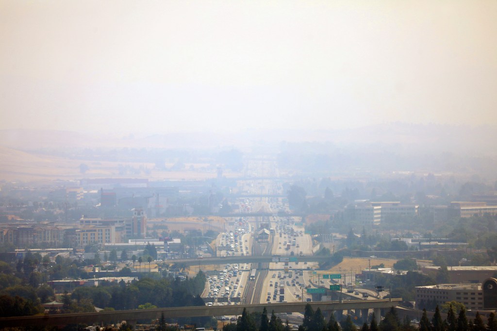
On the penultimate day of the month, nature reminded the Bay Area of how August has often felt and smelled over the past few years, while offering the region a reminder — mostly from afar — of the danger that usually comes with it.
With a Spare the Air alert already in place Wednesday, air quality pollution figures soared around the region, and the National Weather Service issued its first red flag warning in more than a year. Temperatures crept toward the 100s in the Bay Area’s hottest places and moved well into the 90s throughout the region.
Additionally, PG&E began a public safety power shutdown that was expected to affect approximately 8,400 customers in small portions of Napa, Colusa, Glenn, Lake, Shasta, Tehama, Yolo and Butte counties. The Pit River Tribes and Grindstone Rancheria also were expected to be affected, according to the utility. The shutoffs are meant to prevent sparks that could cause a major wildfire in wind-whipped winds.
Much like weather in other months of 2023, so far it seems the summer warmth has defied expectations in some ways.
“That kind of speaks to the broader scale patterns,” NWS meteorologist Brian Garcia said of the milder weather pattern. “It’s been different.”
The air quality early Wednesday drove that distinction home. According to PurpleAir, a real-time air-quality measuring service, fine particulate matter rose slightly above 150 in areas of central Contra Costa County and above 100 throughout the East Bay. Anything above 150 means the air quality is unhealthy for all groups. Anything between 101-150 means those with sensitive lungs may struggle.
The bad air caused a few reported cancellations of youth sports and other outdoor events in the Dublin and Pleasanton areas.
Closer to the water, the air-quality index ran between 50 and 100, meaning the air was moderately healthy.
Still, dirty air has proven to be more of a rarity so far this year. The Bay Area Air Quality Management has issued five Spare the Air alerts in 2023. They issued nine in 2022, 16 in 2021 and 52 in 2020.
An air-quality advisory is set to remain in effect Thursday, according to the district, but was not in the forecast for Friday.
The extreme fire danger also has not reared its head as often as some may expect at this time of year. The weather service issued its first red flag warning for dangerous fire conditions since October 2021. The warning covered the North Bay interior mountains, especially eastern Napa County, and was set to run from Tuesday night through Wednesday evening. Napa County Fire and Cal Fire officials reported no major new blazes in the dangerous areas by about 3:30 p.m. Wednesday.
As for the heat, Labor Day weekend temperatures were expected to stay in the 80s in the hottest parts of the region at least through Sunday, with the chance of cracking 90 on Monday. That’s far different than a year ago, when the Bay Area approached the weekend preparing for a blistering heat wave that eventually took some record-breaking temperatures past 115 degrees on the holiday.
“We’ve been stuck with a quasi-stationary area of a low trough pretty much all this summer,” Garcia said. “Rather than an inflated high-pressure bubble sticking over us and keeping us hot, we’ve sat there with a weak system off the coast, and keeping the flow from the ocean onto land. That’s kept the heat very moderate.”
Winds were expected to be moderate to heavy in areas of the North Bay. The weather service said Mount Saint Helena felt wind gusts of 43 mph early Wednesday, and sustainable breezes of 25-30 mph were forecast in the areas where PG&E scheduled its power shutoffs.
All of it should begin to calm down Thursday, Garcia said. Air sent from the offshore trough will bring cooler temperatures and cleaner skies by Friday, and even cooler temperatures and easy-to-breathe air on Saturday.
𝗖𝗿𝗲𝗱𝗶𝘁𝘀, 𝗖𝗼𝗽𝘆𝗿𝗶𝗴𝗵𝘁 & 𝗖𝗼𝘂𝗿𝘁𝗲𝘀𝘆: www.mercurynews.com
𝗙𝗼𝗿 𝗮𝗻𝘆 𝗰𝗼𝗺𝗽𝗹𝗮𝗶𝗻𝘁𝘀 𝗿𝗲𝗴𝗮𝗿𝗱𝗶𝗻𝗴 𝗗𝗠𝗖𝗔,
𝗣𝗹𝗲𝗮𝘀𝗲 𝘀𝗲𝗻𝗱 𝘂𝘀 𝗮𝗻 𝗲𝗺𝗮𝗶𝗹 𝗮𝘁 dmca@enspirers.com


